
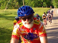
For those interested in bicycling vacations, you may read about Jim and Sylvia Schroeder's spring break vacation on the Natchez Trace in Mississippi. As usual you may click on the photos for larger versions.
By Jim Schroeder
March 30, 2013
We started our Spring break north of Nashville with dinner with the Shirley's at Calhouns, a fancy BBQ place. We did the Nashville thing on Friday and visited Willie Nelson's museum and gift shop. We skipped the expensive museum, but we did get our cache of souvenirs. Next door was Cooters, the authentic Dukes of Hazard museum and it was the right price, free. Next was downtown and Broadway, Ernest Tubbs Record Shop, Raymon Auditorium,the original home of the Grand Old Opry, and Puckett's Grocery and Restaurant for lunch. We then drove to Hohenwold via the Natchez Trace that we wouldn't be riding. They finished the entire Trace as of 2005, about 13 years after I had ridden it with Jon Adair. An architecturally acclaimed bridge and thirty miles of rolling highway awaited us before we got to the town of Hohenwold.
Sylvia and I rode an out-n-back of 39 miles to and on the Trace. We first stopped at Tina's General Store to load up on snacks, but couldn't find any moon pies. The traffic picked up a bit as we got closer to the Trace. First, there was the Meriwether Lewis Memorial, and we learned of the unfortunate demise of one of the exploring duo of Lewis & Clark. No traffic, smooth pavement, and overcast: what more could a couple of cyclists want. Well, a little warmer (51 degrees) and some sun would've been nice.


We were buzzed by a Home Depot semi, and I immediately called 911. No commercial vehicles are allowed on the Trace, and I hope that the ranger pursued this and fined Home Depot. I'm a Lowe's man!
It was a great first day of riding with the long inclines and 40mph declines. We saw some nice falls and a few wild turkey. Unfortunately, the 3pm rain came at 2pm; confused with the time zones maybe? So, the last five miles were in the rain. Mexican food at Rio Colorado for dinner.
March 31, 2013
The plan was to ride all the way to Tupelo, a daunting 130 mile trek. But, Sylvia wanted to leave the hotel when I did, so she drove me to the Trace and leapfrogged me along the way. Every now and then it would sprinkle a little and I'd put on the jacket and then take it off. I was riding well, until those long inclines sprang up. The average speed that I'd built would dwindle down, so my goal for the day now became >15mph. By the time I got into Alabama, the rain stopped. In my mind I was screaming, "Roll tide!". This state was God's country. I even saw my shadow a couple of times! But as I was crossing the Tennessee River, not the state's border, the rain came back pelting me, and then a radar yellow downpour. Sylvia had no where to stop, so I told her to go ahead to the first turnout available. Well, two miles of uphill later, this almost run over sopping wet of a cyclist found the waiting Subaru. New plan: check the weather radar and wait it out and what the heck, drive some down the road but not too much. I still wanted the 100, not 90! So, even with a few drops still around, I hopped back on the bike and forged ahead. After awhile the rain stopped and I was in time trial mode to finish strong. 102 miles and 15 mph.

April 1, 2013
Today, was a loop on the tandem northwest of Tupelo. Our first introduction to Mississippi was the rumble divots on the narrow shoulders of the state highways. Oh well, instead of riding over on the shoulder, I had to stay two foot in the lane, still mine, and slow down the auto and truck traffic. We finally turned onto a country road, and the ride was the best. Phlox growing wild covering whole lawns, the red buds starting to appear. We even spotted a harvested cotton field with a few remnants sticking around. The popular local route was a good find from "Ride with GPS" and we even went by a Civil War Trail monument documenting the battles around Tupelo. It was odd that the north was called the enemy in all the depictions. And here we were, Yankees on a blue and yellow Union tandem. We got back to our hotel via the Natchez Trace, and we stopped at the Park Service and learned more about the history of the Trace. 29 miles
April 2, 2013
I left Tupelo at about 9am with a cold northeasterly tailwind. Despite a bright sunny day, it was a chilly 52 degrees. Today's route to French Camp was rather dull, but the riding was good. Sylvia would drive about 15 to 20 miles ahead, and wait while reading her book. The trees were all budding out with many redbuds inter dispersed. The wildflowers were flanking the highway, whites, lavenders, yellows, and crimson sorts keeping my sights occupied while my legs did all the working. I spied the first two dogwoods of the trip about ten miles before my destination. The tailwind died down, and the temperature shot up to a high of 65 degrees. All layers were shed as I sped to French Camp Bed & Breakfast. This small town is all about this Christian academy for troubled youth and families desiring a fresh start. Known as "the town with nothing to do", French Camp is a divine destination for this wearied traveler. 90 miles, 16.8 mph

April 4, 2013
We didn't ride the tandem yesterday as it was too cold, too windy, and off and on raining. So, we drove to Starkville to check out my son-in-law's alma mater, Mississippi State University. We saw one of those SEC football stadiums. Boy, do these people love football. We also had some lunch at one of the tailgater's favorites, Dooey's, for some catfish and pulled pork.
The forecast didn't sound good for today, so a little drizzle to start the morning was a hopeful sign as I left French Camp. The pace was surprisingly fast and steady as I was averaging 17mph or so the first 30 miles. I slowed a little, and the drizzle finally ended, yet it was still cloudy and cool. I saw a few birds, some egrets and herons, and I rode along a 20 mile long reservoir before reaching Jackson, and then the excitement began. In order to get to our hotel, Sylvia had to drive with an uncooperative GPS, "Michelle", while I tried to keep her on course while I was an eighth of a mile behind. After a couple of dicey left hand turns, we finally made it to our hotel, where our rooms were booked on the wrong days. Oh well. 83 miles, 16.3 mph.

April 5, 2013
We decided to ride an extensive Multi-use Path system that paralleled the Natchez Trace for about 12 miles. Twenty years ago, I remember that there was no parkway and a lot of resistance to it in Jackson. Twenty years later, Jackson got the Trace and Ridgeland got those paths. Although Sylvia didn't like the traffic getting to the paths, it was a rather enjoyable 33 miles. We even took pictures of bridges for Ron Brown. Unfortunately, the rush hour traffic getting back to the hotel was quite stressful especially when a right turning car turned into our path.

April 6, 2013
I started my last day just north of Jackson with a beautiful sunny morning as Sylvia dropped me off at the ranger station. There were many joggers stretching before they embarked on their Saturday morning runs on the bike path. I saw quite a few more bicyclists on the Trace, also. There were some local Jackson riders meeting up at any of the turn-off points and also some loaded tourists just starting their journey on the Trace. The speeds were a little slow due to a pesky 5-10mph headwind the entire distance. Sylvia leapfrogged me every 20 miles or so. At the last stop she toured the Mount Locust Inn or stand. She the waited for me at the southern terminus to pick me up so we could hunt down the hotel in Natchez. We enjoyed some southern cooking at a resurrected old train station along the Mississippi River and the we drove around looking at all the antebellum mansions of Natchez. 105 miles 15.6 mph


No comments:
Post a Comment