From CE Taylor
The OWLS had 10 riders on our Robinson Road Ride tonight. At our first stop at Mt. Gilead two riders went down Mt. Gilead while the rest of us rode to Tunnel Road via Hwy 45. Traffic wasn't too bad and we were spaced out in small groups so cars were able to pass us more easily and safely. We cruised down Robinson and regrouped at Old 37 before turning back towars town. We climbed Firehouse Hill for the second time since Saturday. I wonder how many times BBC riders have climbed that hill? We rode past Griffy and it was nice to see the lake filled with water again.
I will admit that I almost bailed out on the ride tonight. As our group finished the ride back through town, a few other OWLS said they had felt the same way. We all agreed that we were glad that we went because it was a good evening for a ride. The cool temperature and light sprinkles that we had several times during the ride only added to our adventure.
Wednesday, April 25, 2012
Nashville and Bear Wallow
Saturday was a cool--maybe even cold--day for a long bike ride. But we still had about 15 riders up to doing it. The plan was the traditional Ye Olde Hilly Route to Nashville for 55 miles. We quickly split up into two or three groups. My trailing group decided to take the slightly shorter Owl Creek option down to Helmsburg Road rather than the mapped Lanam Ridge. Pretty quickly we hit the climb on Helmsburg Road into Nashville. Once there we met up with most of the leading group at the convenience store in Nashville. Many of them left pretty promptly while a few held back to join our "owlish" group. Probably for the last time the year several people opted for hot chocolate over cold soda or GatorAde. Soon we headed out for our next big climb up Bear Wallow. Along the way Mike just couldn't help stopping to photograph a couple of election road signs:
 Mike tried hard to get us to stop at the Port Hole Restaurant at Lake Lemon for some of the real thing. But he couldn't find any takers. So we headed up our third climb of the day on South Shore instead. We enjoyed the fast ride down Robinson Road, dealt with our fourth and last climb on Fire House Hill in workmanlike fashion, and finished up taking the B-Line Trail through town as far as Grimes Lane. Home to home my GPS recorded 56 miles at 13.7 mph, with 2255 feet of climb. We all agreed it was a good day.

Friday, April 20, 2012
Tiësto
This Thursday' evening ride was actually named "Up Victor", for its big climb(s). Although no one admitted planning it, five people showed up wearing last summer's bright yellow RAIN 25th anniversary jerseys:

We thought we'd stop and take a look at the car wreck site on Victor Pike near Fluck Mill where 3 young guys were killed Monday night/Tuesday morning. We had assumed they had missed the turn, but in fact the site of the wreck came well before the intersection. It was marked by hand made crosses and a damaged tree. But we didn't stop.
After we made the turn onto Rockport for the ride toward home we soon noticed some strange background noise. Pretty soon the traffic got really heavy and we came upon the beginnings of a very large outdoor concert of some sort. It turned out to be Tiësto, a loud electronic DJ/light show/fireworks affair with all kinds of students out for an early start to Little 5 weekend.

The site was Pic-a-Chic Farms, located about halfway out along Rockport, at the corner where there is a quick right then left on the map:

We kept on moving toward town, but the excess traffic--cars, buses, suvs, Mercedes, cabs, pedestrians, everything--eventually drove us off of Rockport. A couple of wise people left on Tramway. The rest of us took Bolen over to Victor and went back in on Victor.
Overall this was one of our shorter rides recently. But it had quite a bit of climbing, over 1300 feet in 24 miles home to home. But we definitely saw more unusual sights than on most rides.
Tuesday, April 17, 2012
Shuffle Creek
Here's what this evening's OWLS Shuffle Creek ride looked like in profile:

Dangerous Roads and Road Sharing Tips
From Jim Schroeder
A recent midweek century went to Cataract Falls, where I again had the honor of showing Dana Marsh, a BBC rookie, the sites of southern Indiana. She loved the falls and the general store, but after 75 miles of hills, she wasn't too happy with the hill monger regarding more hills and a new gravel road at McVille.
When we were at the Spencer Shell station, a man came up to us asking about our route back to Bloomington. A very nice pillar of the community type was he, in the risk management (insurance) business. We said IN-43, and then he started going off on us very politely. He drives on that road four or five times a day, and says it's already a dangerous highway, and then when motorcyclists, logger trucks,and now "you Bloomington bicyclists" are on the road, some bicyclist is going to get squeezed into a guard rail or over down into the ravine. We agreed with him that we risk our lives every time we mount our bicycles, and how we depend on our rear view mirrors. He felt that we should all have tall flags on our bicycles. His thinking was that every vehicle would automatically slow down and proceed with caution. He wanted us to tell everyone of our peers through a bicycle blog. So, here I write to better our relations with those cars.
I also just happened to be reading the weekly e-mail magazine, Road Bike Rider. This is a great weekly read for all of you road bikers. It's worth a look and it's free. They sell e-books, etc. through this. They talk about the same issue but for the cyclist.
Below is a great tutorial:
Taking a rest on a recent ride, I was talking to a gentleman sharing the bench with me at Stone Mountain Park. He was telling me that he got scared and stopped riding his recumbent after one too many close calls with cars, and after a police officer pulled up next to him in his squad car and told him he was too low to the ground and difficult to see.
I asked about the flags I sometimes see on recumbents. He told me he flew 3 on his! And still he was somehow difficult to see, according to the officer. I told him I’ve had countless experiences on my two-wheeler in which drivers have simply looked right through me, no matter how bright my jersey or jacket was that day.
When I checked my email after that ride, I had one from an RBR reader in Australia, Court Gettel, who sent a link to an article about exactly the same phenomenon. I had never heard it before, but it seems that the Aussies and the Brits have an acronym for what drivers invariably say in the form of an excuse:SMIDSY – “Sorry, mate, I didn’t see you.”
The author of that article, Michael O’Reilly, recounts hearing something very similar from the driver who hit him head on, having pulled out in front of him even though O’Reilly had the right of way. He survived with no major injuries and was back on the bike fairly soon. But he became an angry rider, often yelling at miscreant drivers and never trusting them to see him or give him the right of way [which he believes – and I agree – makes him safer].
In summarizing his post-crash feelings of fear and rage, he makes some excellent points:
“The problem is that the stakes are so different for cyclists and motorists. If a car and a bike collide, the motorist goes to the panel-beaters [I suppose that’s body shop in American English]. The cyclist winds up in hospital; or a wheelchair; or the morgue.
“But motorists often don’t understand that what they see as a happy outcome – “whew, that was close!” – is a near-death experience for a vulnerable road user. And that’s why the cyclist is ranting.
“After a while, I calmed down again. I realized aggression wasn’t helping anyone, least of all me. I smile at fellow road users, I wave to say thanks, and if someone nearly wipes me out, I try to have a calm, polite chat with them if I get a chance. Mostly, they are genuinely sorry.”
Road-Sharing Tips Always Worth Mentioning
If you have to deal with cars on a regular basis on your rides, following a few basic tenets of road safety can help you avoid that cringe-worthy acronym, SMIDSY, or its counterpart in whatever your native language.
See What’s Ahead
Stay focused on what’s going on around you, and what’s up the road. Be aware of all the cars around you, especially those that might make a sudden right turn in front of you. If you see movement, slow down and prepare to stop. (On a ride the other day, a van pulled over to the curb right in front me, with no warning. I slowed and passed the van, as the driver yakked into the mobile phone glued to his ear.)
If you’re nearing an intersection with a traffic light, look up the road to gauge when the light might turn from green to red – and whether any oncoming traffic might turn left into your path. This is especially necessary if you’re riding in a bike lane that’s part of the road. A left-turning motorist may not even realize they need to check the bike lane for oncoming traffic. If you can see them, assume they don’t see you.
Direct Traffic
Often, roadies will come across a driver whose intentions are good, but in trying to do you a favor – for instance, letting you cross in front of them when you don’t have the right of way – they actually endanger you. If you take them up on their offer, you could get hit by another car that doesn’t have the same kind intentions or is completely unaware of the other driver’s plan. In cases like this, channel your inner traffic cop. Stop where you are and wave on the well-intentioned driver. It’s better, and safer, for all the vehicles in such a situation to stick to the rules of the road. Thanks for the offer, but no, thanks.
Make Yourself Visible
I’ve long since lost count of the number of times drivers have looked right through me and pulled out in front of me – even when I look like a giant rolling banana in the brightest yellow jacket I own. It makes sense to give yourself every chance to be seen – especially in overcast or gloomy conditions – by wearing bright colors, reflective materials and proper lights at the appropriate times. Even if you’re fashion-conscious in your riding gear and like darker colors, contrasting shapes and colors can help you stand out.
Minimize Distractions
Of a human’s 5 senses, we have two available to help us navigate the roads: sight and hearing. Paying too much attention to your on-board computer takes both your mind, and your eyes, off the road. Only after checking your surroundings should you briefly glance at your computer. You can pore over your metrics later, when you’re at home. And while I personally do not believe in using any form of ear buds during a ride, I know some riders do like to listen to music and such when on the bike. Doing so at a low-enough volume to be able to hear everything going on around you is the only way that the idea is acceptable.
Low Expectations, Indeed
I’ve mentioned before that, raising 2 boys, my wife and I have come to expect them on occasion to do the absolute most mindless thing. In that respect, drivers and boys are not dissimilar! I expect drivers to do the stupidest possible thing, as well, and I try to be ready for it if they meet my expectations. Never think you know what a car is going to do. Expect it to turn in front of you, pull out into your path, etc. And be ready for it.
See Eye to Eye
One way to at least partially overcome this lack of certainty is to try hard to make eye contact with a driver in a tenuous situation. For example, if you’re cruising down a road and come up on a car at a stop sign on a side street (that is waiting to turn onto your street) – do your best to stare down the driver until you can see that the driver sees you. Turn your head to help send the message that you’re looking at them (simply shifting your eyes behind your cycling sunglasses is completely useless). Making this connection in any difficult traffic situation is a necessity on the road.
And remember, if you do have a close call, vent if you must, but it’s likely to result in a defensive response from a driver. The better tack is to follow the advice of Michael O’Reilly and try to calmly educate the motorist so that they – hopefully – don’t repeat their mistake. Click to read his complete article.
Be Safe, and Enjoy your ride!
John Marsh
Editor & Publisher, Road Bike Rider
Thursday, April 12, 2012
Up the Dam Hill
We had a nice group of 15 riders out for a cool, clear ride of about 26 miles. Fortunately some people had reviewed the posted map, since I was totally confused about the route, having downloaded the wrong map. But people got us on the right path for the OWLS Old 37-Strain Ridge Route otherwise known as the "Up the Dam Hill" ride, climbing the long hill on the road between Old 37 and Strain Ridge.
The group was relatively fast and stayed close enough together that our early regrouping stops got skipped. We did eventually regroup on Strain Ridge after climbing the Dam Hill. Then we regrouped again one last time at the PO in Smithville:
 As I was taking this shot, the fast training group appeared and zoomed by. I was able to get a quick look in the camera before they passed by:
 Overall the ride was 26 miles, with an average of about 14.7 mph and a little over 1000 feet of climbing. My home-to-home average was about 14.4, throwing in a couple slower miles back and forth to the church. It was a good evening to be out.
The group was relatively fast and stayed close enough together that our early regrouping stops got skipped. We did eventually regroup on Strain Ridge after climbing the Dam Hill. Then we regrouped again one last time at the PO in Smithville:


Triple Creek
Old timers may remember that when we were working on developing the midweek training rides, perhaps 10 years ago, club member Al Abbott contributed a few new rides, including the Triple Creek Ride. Soon Joe Anderson adapted it for the new club map packet. And now the OWLS continue to use it with a version adapted to our starting place at Sherwood Oaks Church. For this version we also avoid Highway 45 and do Kerr Creek in both directions, as well as Brummets Creek and Gettys Creek. And don't forget the climb on Mt. Gilead and the killer climb on Fleener. My GPS registered over 20% on Fleener at one point.
The weather on Tuesday evening was cool and windy. The result was that we had just 9 riders out for this venture. The ride was also one of the longest we've done in an evening so far. But with the relatively small group we were able to keep together pretty well. Most of us had on tights or knee warmers and a jacket or vest and arm warmers. I tucked a pair of full-fingered gloves in my pocket on the way out the door and was happy when I finally got a chance to switch over to them.
Klaus liked to scoot out ahead. Then we'd arrive at our re-grouping spot and he'd just be sitting there relaxing!
On the return along the valley on Kerr Creek, Klaus got ahead again. When we saw him he was standing in the road. And when we got closer we saw that he was looking in the other direction. Finally we realized he was setting up a photo-op and we were to continue riding while he tried for a shot of us going by:
 Home to home I had just over 28 miles at 14 mph, with GPS-registered climbing of over 1000 feet.
The weather on Tuesday evening was cool and windy. The result was that we had just 9 riders out for this venture. The ride was also one of the longest we've done in an evening so far. But with the relatively small group we were able to keep together pretty well. Most of us had on tights or knee warmers and a jacket or vest and arm warmers. I tucked a pair of full-fingered gloves in my pocket on the way out the door and was happy when I finally got a chance to switch over to them.
Klaus liked to scoot out ahead. Then we'd arrive at our re-grouping spot and he'd just be sitting there relaxing!
On the return along the valley on Kerr Creek, Klaus got ahead again. When we saw him he was standing in the road. And when we got closer we saw that he was looking in the other direction. Finally we realized he was setting up a photo-op and we were to continue riding while he tried for a shot of us going by:

Saturday, April 7, 2012
Cool, bright and clear
The Saturday ride calendar shifted to 10 am this week. Unfortunately the temperature cooled off too. It seemed like it was still in the upper 40s at ride time. Nonetheless we had a good group of about 25 riders out for a relatively short ride looping down to the Cedar Bluffs Nature Preserve on Ketcham Road. If you haven't visited this Nature Conservancy site, it's well worth an afternoon out for a hike.
Our leader Keith Vogelsang (aka club president) altered the standard club map both for going out and coming back into town. We went out of town following Grimes, Rogers, and Church, to Victor. On the way back in we took Victor, Church, Walnut Street Pike, and Cardinal Glen.
 We all gathered up at Cedar Bluffs, near the sharp bend on the SE part of the map.
 We then gathered up again at the service station in Harrodsburg. At that point almost half the group opted to go off on a longer route, essentially following the club's "Funky 50" route. Here's a map recorded by Lyle May, eventually covering 57 miles:


Our leader Keith Vogelsang (aka club president) altered the standard club map both for going out and coming back into town. We went out of town following Grimes, Rogers, and Church, to Victor. On the way back in we took Victor, Church, Walnut Street Pike, and Cardinal Glen.


Meanwhile the rest of us headed back toward town on Old 37. At Ketcham Turn About we headed back along Ketcham to Victor and from there largely followed our outgoing route in reverse, ending up with about 29 miles for the day. Here's our leader Keith at the Ketcham gathering up point:

Thursday, April 5, 2012
Fluck Mill and More
We had a cool ride this evening, doing a version of the Fluck Mill Ride, with temperatures in the 50s. Altogether we had 15 riders. Just the right size group. We did our usual Snoddy to Ramp Creek and regrouped at the church in Smithville. Once we got to Victor Pike we (well, all but one of us) turned west on Tramway and looped back on Rockport and Bolen before continuing back into town via Victor, Church Lane, and Schacht Road.


The main part of the ride was 23.3 miles, averaging 14.1 mph (at the rear of the group), with total climb in the 1300 foot range. Allowing for the ride to and from the church I had 26.3 miles. A nice ride!
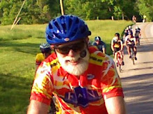
Klaus took the following shot during the ride. As he said, "Days are getting longer and it's great to ride after a long day at work."

Wednesday, April 4, 2012
OOWLS to the Airport
The OOWLS (that's the "original" OWLS) did a version of our 23 mile Airport Ride with a total of 16 riders. Before the new Intermediate Group started this week we were often having 25. But now that we are separate we've got even more between the two groups. It's definitely easer to manage two smaller groups.
We had full regroups at the Clear Creek Trail and at Monroe Hospital.
 Eventually we split into two smaller groups when a big log truck passed some of us on Garrison Chapel Road. Occasionally our second group got just within sight of the lead group, but never caught back up.
I finished with 25.5 miles averaging 13.3 home-to-home. My GPS recorded 996 feet of climb, even though our route mapped predicted 1500.
We had full regroups at the Clear Creek Trail and at Monroe Hospital.
I finished with 25.5 miles averaging 13.3 home-to-home. My GPS recorded 996 feet of climb, even though our route mapped predicted 1500.
First Intermediate Ride
From Tom Reynolds
Eighteen riders joined the inaugural Intermediate Ride on Tuesday. We left Bryan Park after some quick temporary repairs to one of Jerry's pedals that kept trying to escape from the rest of his bike. We rode through the neighborhoods to Smith Road then north on Route 45 to Mt. Gilead where we did a quick regroup. Then down the big hill on Mt. Gilead and up the easier side, over to Tunnel where we took a bit longer to regroup and add some fuel in bar or gel form. We then rode over the always fun Robinson Road to Old 37 and up the always less fun Firehouse Hill to our final regroup at the firehouse where the group picture was taken.

John, who is riding very strong this year, had an average speed of 16 at this point. Jerry also showed some speed by catching up to us here after stopping by his house to more securely mend his pedal. From there we returned to Bryan Park via Cascades. Bill broke a spoke and hopped on the bus to get home from the Stadium but otherwise everyone made it back okay.

My average speed, Park to Park, was 15.7 mph although we flew across Robinson at well over 20. The ride distance was 23.7 miles.
Eighteen riders joined the inaugural Intermediate Ride on Tuesday. We left Bryan Park after some quick temporary repairs to one of Jerry's pedals that kept trying to escape from the rest of his bike. We rode through the neighborhoods to Smith Road then north on Route 45 to Mt. Gilead where we did a quick regroup. Then down the big hill on Mt. Gilead and up the easier side, over to Tunnel where we took a bit longer to regroup and add some fuel in bar or gel form. We then rode over the always fun Robinson Road to Old 37 and up the always less fun Firehouse Hill to our final regroup at the firehouse where the group picture was taken.


Subscribe to:
Posts (Atom)