
I guess you are never too old to do crazy stuff. So when the opportunity presented itself to join Jim Schroeder and Sylvia Stoub for a weekend bicycle jaunt to North Carolina, I jumped on it. The primary goal of the trip was an ascent of Mt. Mitchell, North Carolina, which at 6,684 feet elevation is the highest peak east of the Mississippi River. Starting in Swannanoa, just east of Asheville, Jim’s route involved a 92 mile loop ascending about 5,200 feet to top of mountain. The route and profile are shown below.

We left Bloomington about 7:30AM on May 18. A detour on I-75 due to a landslide on Pine Mountain, Tennessee slowed us a little, but we arrived at the campground in Swannanoa in time for a leisurely warm up ride out and back on the Blue Ridge Parkway. Back at the campground we joined fellow BBC’er Jim Isenberg and his friend Ann for a great North Carolina barbeque dinner. We spent the night in quaint camping cabins nestled amongst rhododendron and mountain laurel along a rushing mountain stream.
Early Saturday morning we started the mountain assault. Isenberg and Ann had decided to try the assent from the west starting at the Appalachian Fork Art Center about Mile 86 on the map. Schroeder and I cycled east generally on, or paralleling, US 70 through Black Mountain to Old Fort where we found a nice hole-in-the-wall breakfast joint. I tried the liver mush – interesting, but I would not do it again.
Sylvia turned around at Old Fort and headed back west. Proceeding east from Old Fort we navigated about 2 miles of gravel (this seems to be a theme on some of Jim’s rides) on Old Greenlee Road and at about Mile 26 turned north on NC 80. There should be a sign that says the fun begin here. Starting at an elevation 1,260 feet, one slowly climbs 2,100 feet over the next 12 miles to the Blue Ridge Parkway. This is the route followed by the organized Assault on Mount Mitchell which was to happen the following Monday, May 21. We saw painted markings on the pavement at this point indicating 74 miles. So, these Assault dudes who start in Spartanburg, South Carolina have got 74 miles on their legs before they get to the fun stuff. We allowed that a leisurely ride up the mountain two days before was preferable.
Never think the Blue Ridge Parkway is flat. It ain’t. Once on the Parkway at Mile 38 you are faced with another 3,200 feet of up to get to the top of Mt. Mitchell. The grade is reasonable, but there is a lot of it. There are an irritating number of Harley Davidsons and enough gnats get plastered to your face to make you unrecognizable to your next of kin. Speed is not an indicator of progress. Set your GPS to display elevation.
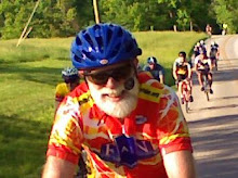
About Mile 49 we reached the turn off of the Parkway to Mt Mitchell. The grade steepens. I was running low on fluids. But, about a half hour later you enter Mt. Mitchell State Park and enjoy gorgeous views along the crest of the Appalachian Blue Ridge. Here is Jim at the top.

After a brief rest, Moon Pie, Coke, and other junk we started down. This is not what you think. There is still a remarkable amount of uphill to do along the rolling Parkway. This adds a lot of climb to the total loop. Finally at Craggy Gardens (Mile 68) we hooked back up with Sylvia and began to descend. The 14 mile downhill back to US 70 is spectacular, slicing through dark mountain forests and open glade areas, and yes, the occasional tunnel requiring a bike lite. On the steeper parts you just pretend you are a car and keep up with the traffic. The Parkway dumps you back on US 70 just east of Asheville. A little ride east and a nasty final climb gets you back to the Swannanoa campground. This is a pretty good “almost century”, and a hilly one at that. Owing to a couple of missed turns and some exploring we finished with 94 miles. The GPS recorded a total climb for the day in excess of 9,000 feet.
After pizza and beer in Ashville we returned to the campground and compared notes with Jim Isenberg and Ann. Their route up was our route down. Their up and back to the top of Mt. Mitchell totaled 65 miles. I think they both wished they had done the loop having found their ascent not too difficult.
On Sunday, both Jims, Ann, and I did a another Schroeder-designed 55 mile loop called the Hill of Some Concern, with Sylvia providing SAG support. It features a little climb of the same name (800 feet with, as Ann counted, 18 switchbacks). This little puppy is intense in spots and you learn to ride the outside of the lane where the grade is not as steep. There is an interesting sign at the top which I was glad I did not see at the bottom.

The ride finishes with a nice 10 mile downhill back to Lake Luer, NC. We finished the ride about 3:30 within sight of the spectacular Chimney Rock, now a North Carolina State Park.

After saying our goodbyes to Jim and Ann, and a mandatory ice cream stop up the road we began the long trip back home. Bicycling stories abounded which made the trip seem shorter. Still, it was 1:30 AM before we rolled back into my driveway.
Crazy as a weekend 900 mile round trip may seem, this sure was fun. Thanks to Jim and Sylvia for organizing. This seems to be becoming an annual club event. I think I’d do it again.


No comments:
Post a Comment