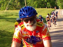
We had another good evening for biking. The OWLS had 19 riders, including one on his first club ride. Allan Edmonds and Tom Reynolds got the group organized, with Allan getting everyone to introduce themselves, while Tom went over the designated route, which we call Old 37 to Strain Ridge (link to PDF map). Tom recruited John Bassett to serve as sweep, which he did admirably. Tom planned out our standard regrouping spots on Victor just after crossing 37; Ketcham where we switch onto Old 37; Strain Ridge just after climbing that dam hill; and the PO in Smithville. Allan was just about to send us off right on time, when Kathy Avers announced that she had a flat. As usual several guys moved over to help. It was good that Kathy had her car there and a floor pump. The guys got the tube swapped out and ready to go in just 9 minutes. Pretty good for a bunch of amateurs! Our latest start in two years!
Everyone did a good job of staying together even though this turned out to be one of our faster rides. Somewhat surprisingly all but a couple of riders decided at the Post Office to take Ramp Creek rather than Fairfax back to the church.
We were coming in along the Waterworks route on Handy when Kathy had her second flat of the night! Again several people stopped to help, but for safety's sake it made sense for most of us to continue on toward home.
According to a note posted on the BBC homepage, Google Earth can now import and display data directly from a GPS. So we gave it a try. Here's a screen shot of the evening's ride displayed in Google Earth. Next project is to figure out to link to a "live" version in Google Earth.
Overall this was a bit faster than our typical OWLS ride. I averaged 15.2 mph for the basic 26 mile loop, tempered a bit to 14.3 by the time I added in 4.5 miles round trip between my house and the start. We climbed a bit over 1500 feet total and had a downhill max of just over 35 mph.
Thursday, June 24, 2010
Subscribe to:
Post Comments (Atom)


No comments:
Post a Comment