By Jerry Arvesen
From Sunday, June 19 through Saturday, June 25 I participated in the 17th annual Bicycle Tour of Colorado (BTC). This year’s tour started and ended in Central City just west of Denver, and promised the Peak to Peak Highway, the crossing of Trail Ridge Road in Rocky Mountain National Park, Steamboat Springs, Glenwood Canyon, a day off in Glenwood Springs, and finishing with Vail and Loveland passes.
My wife, Janice, and I drove out and cycled in South Dakota for a few days en route to Boulder, where she was to stay with friends while I was riding the BTC. Our first pedal strokes were in Badlands National Park, marking my first time in South Dakota. Fellow BBCer Jim Schroeder had kindly given us some SD cycling routes, which we followed religiously. The Badlands is laid out as a rolling end-to-end road through the major sections of the park, so Janice and I did a 45 mile out and back. It was a warm and sunny day, with little traffic, and we saw plenty of prairie dogs, mountain sheep, and moonlike scenery.
JANICE IN BADLANDS NATIONAL PARK
After a drive to Custer State Park, the next day we rode to Crazy Horse Memorial and Mount Rushmore. The Crazy Horse mountain carving was started in 1948 and is still far from completion. Designed to be about 10 times higher than Mount Rushmore, it’s no wonder. The terrain this day was much more challenging, with 2-3 mile long uphills, major road construction, and heavy tourist traffic. Fortunately, we had shade and rest breaks as we lingered leisurely at the attractions. In the state park we also had heavy bison traffic, and at one point a line of vehicles had slowed down to gawk at a herd on the shoulder of the road. Having already seen my share of these creatures, I proceeded ahead only to have one grunt and take a step towards me. That resulted in my fastest sprint of the week! 59 miles for the day.
JANICE & JERRY AT CRAZY HORSE MEMORIAL
ONE OF OUR FOUR-LEGGED FRIENDS
After a day off, we headed to Spearfish Canyon in the northeast corner of South Dakota. This area was a nice and beautiful surprise. Our hotel was fortuitously located in a rural setting right on the highway, and we enjoyed waterfalls, rugged pine forests, rock outcroppings, and wildflowers as we rode 13 gradual miles downhill at the start of our ride. Unfortunately, we had to pay the price, as we had two major four mile uphills with traffic starting to build around the gambling mecca of Deadwood. The heat and hills were starting to get to us, and we slowed our pace considerably. These hills reminded me of our SR446 causeway hills, but once at the top we coasted and cruised easily for about six miles back to our hotel, for a total of 48 miles for the day.
JANICE IN SPEARFISH CANYON
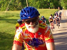
On to Colorado, where Janice indulged me in my quest to see if I could conquer the mountains of Colorado. We had seen about half of this year’s BTC route on a family vacation about 15 years ago, but fatherly duties kept me from riding significant miles. I was curious if my middle-aged, southern-Indiana legs could keep pace with the serious riders from mainly western states that this ride attracts. Janice joined me as a bandit on Sunday as we rode the Peak to Peak highway from Central City to Estes Park. The day started out cool and cloudy, then turned to rain as we finished. We were able to get a great taste of the week to come, however, with gorgeous scenery and the thrills of carving the turns on the downhills. I like going fast on downhills…no doubt about it…and the Peak to Peak highway would prove to be one of the best of the week for that purpose. Janice and I got separated towards the end, and I discovered my cell phone was not working because it got wet in the rain, so we had problems hooking up. I got to the school first and started hustling with the tent (instead of watching for her), as the rain had subsided somewhat. Wrong marital choice. My phone would receive her calls but I could not hear her nor could I make outgoing calls. Finally we hooked up, made peace, and met our Boulder friends for dinner. There was a terrific thunderstorm during dinner, and upon returning to camp I noticed my soaked and flattened tent. Bummer! Now I was on my own for the rest of the week, and I had to start off with some wet clothes and gear. It would not get better soon.


JERRY ON PEAK TO PEAK HIGHWAY TO ESTES PARK
No doubt, one of the highlights of the entire BTC was the opportunity to ride Trail Ridge Road through Rocky Mountain National Park. Trail Ridge Road is the highest continuous paved road in the United States, climbing to 12,183 feet and connecting the towns of Estes Park and Grand Lake. The Park Service tries to open it by Memorial Day every year, but this year they couldn’t until June 6 due to the most snow seen this late in the season in thirty years. Even at that, because weather conditions can change rapidly, we were to be prepared for the possibility that the road would be closed for the day and we would have to ride back to Central City and be shuttled to Granby, our next town. We awoke to the promise that a yay or nay decision would be made by the Park Ranger at 5:00 am, then 5:45, then 6:30. Something was happening up there, because the weather wasn’t too hospitable at the school either. I was dressed in my heaviest winter cycling gear; three layers on top, shorts and tights, and full-finger gloves and ear band. I guessed it was about 45 degrees when we got the go-ahead at about 7:30, and there was an en masse cheer and sprint for the road as impatience met with thoughts that we should take off before anybody changed their minds. Why were we so excited about a 25 mile uphill climb? Everybody soon hunkered down in a comfortable gear and cadence. Clouds, mixed with some sun and mist, formed a rainbow over a valley near the entrance to the park, and groups even stopped to take pictures during a sunny moment at one of the major junctions on the road. The more we climbed, however, the more foreboding the weather became. I started seeing riders coming downhill towards me going the opposite direction, and noticed they had BTC stickers on their bicycles. Finally I reached the first sag stop at mile 20, and encountered a huge backup of bicycles and cars, because the Park Service had closed the road due to worsening weather conditions. Crap! What to do? Do we turn around and grab a shuttle bus to Granby? But, wait! Rumor is that they’re reconsidering! Sure enough, the time that I spent refueling was time well spent, as we soon queued up and were released up the road in groups of 50 riders or so.

ENTRANCE TO ROCKY MOUNTAIN NATION PARK & TRAIL RIDGE ROAD
I remember a ride report from RAIN a few years back when it was reported that they “had everything but snow”. Well, this time we had everything but sun. It started raining, then sleeting, then downright snowing with blizzard-like conditions. The wind was fierce and gusting sideways. Despite the sick irony of riding in these conditions and “enjoying” the arctic scenery, my thought was to keep hustling and get off of the summit as quickly as possible, and maybe conditions would be better at lower elevations. What alternative did I have? I stopped at sag stop #2 just long enough to get the pictures to prove it, and the same for the Visitor’s Center at the summit, where I basked in the warmth of the shelter and in my glory of having pedaled to the top. No time for pictures at Milner Pass, the Continental Divide, because it was on the downhill and it was raining heavily. I had looked forward to this long downhill as my reward, but it was hardly enjoyable as the cold, pounding rain made it hard to see and required full concentration. In addition, I thought I could feel my bike shimmying on the descent, a new sensation for my trusty Trek. However, I soon discovered the real reason: I was so cold and was shivering so violently that I couldn’t keep the bike stable. Regardless, I quickly arrived at sag stop #3, where the volunteers and park rangers were hustling us off our bikes and urging us to warm up in one of the many vehicles idling for this sole purpose. My clothes still soaked, but with the worst of the weather gone, I finished the last 15 miles or so to Granby and made a beeline for indoor camping in the gymnasium, required wrist-bands be damned. 65 of the most exciting, harrowing, adventurous miles on the bike I’ve ever had.

STILL BALMY AT 11,000 FEET
SAG STOP #2, TRAIL RIDGE ROAD, JUNE 20, 2011
VISITOR CENTER AT SUMMIT OF TRAIL RIDGE ROAD
The next two days to Steamboat Springs and Glenwood Springs, respectively, were sunny with friendly clouds, dry air and light winds. It was cool at the start, requiring a jacket, which we shed by midday when the temperatures hit the mid-80s. We were now riding in wide-open Colorado, home of big skies, scrubby ranch land, buttes, wildflowers, and a small town every 30 miles or so with the requisite coffee shop and bakery. All that and a mountain pass or two thrown in for good measure. After setting up camp, I enjoyed the beer gardens, live music, and the offerings of the food vendors in the parks in each town. Each cyclist I talked to had their own story to tell of Trail Ridge Road, which seemed as if it would quickly turn into a legendary day. I later found out that I was in the minority of riders who were able to complete the whole route that day, the others needing to be shuttled by bus over to Granby. 90 miles each day to Steamboat and Glenwood Springs.
JERRY STRADDLING THE CONTINENT
After a day off in Glenwood Springs, we headed eastbound to Vail, paralleling I-70, and riding on either US6, US40, or a nice paved dedicated bike path. The weather again was ideal, which helped as we literally were riding uphill for the first 50 miles or so for the day, culminating in a rather steep (for mainstream Colorado) 6-8% grade, eight mile climb up Vail Pass. The little town of Frisco, 20 miles east of Vail, was our destination, and I enjoyed re-kindling my memories and bike rides of our previous vacation in this area. Our camp was at the high school south of town which services Frisco and Breckenridge, and the two towns (and the whole county as well) are connected via a nice separated bike path system. After dinner I rode to “Breck” to meander and get some dessert, and I watched a red fox for a few minutes as it sniffed around the bike path and trotted casually not fifty feet from me. 85 miles for the day.
NEAR THE SUMMIT OF VAIL PASS
Our last day’s route took us past Keystone and Arapaho Basin ski resorts and up Loveland Pass on US6. A-Basin was still open for skiing…amazing to me, but a fellow told me they’re normally open in June, mainly due to their geography and their orientation to the sun. Again we were to start out with at least fifteen miles uphill, and the eight mile Loveland Pass proved to be a make-or-break, as the accumulated miles were clearly wearing on many riders’ legs. Throughout the week, I found that one cannot ride these climbs like the hills around Bloomington…you can’t sustain standing or try to power up them, rather you have to hunker down, take your time, sit and spin, and think of how to solve world peace. There was a celebratory atmosphere at the sag stop at the summit of Loveland Pass, as people took pictures and relaxed, knowing that the week’s last major climb had been completed. The downhill was one of the week’s best, with open views and a fun twisty road to carve. We all came to a quick halt, however, as the Clear Creek Sheriff’s department held us up and released us in groups of fifty or so onto the shoulder of Interstate 70. Riding a bicycle on the Interstate is legal where there aren’t obvious alternatives. In this case we were riding the shoulder downhill for fifteen miles or so at a 5-6% grade, coasting at speeds of 35-40 miles per hour. We had to avoid the grooved rumble strip, road litter, and most definitely the right-hand lane of the highway. At the bottom of the grade, and after the last sag stop, I waited for Janice at our pre-determined meeting point, and watched the riders pedal the last climb into Central City. 49 miles for the day, 425 for the week, 40,000 feet of elevation gain, and a mixed sense of happiness and melancholy as the tour came to an abrupt end.

JERRY AT LOVELAND PASS SUMMIT
Random thoughts:
- The National Park Service rangers had full authority and police power over Trail Ridge Road. While they were incredibly polite, accommodating and well-trained, it was obvious that their word was paramount and a person did not want to get on their bad side. I suspect in all about 40-50 ranger personnel were involved in traffic control and ride support.
- Likewise, the Colorado State Police were in evidence all week, patrolling the route on motorcycles and ensuring that cyclists maintained road decorum on the narrowest roads, and keeping in contact with the sag drivers.
- I saw t-shirts or bike jerseys from RAIN, TRIRI, Hilly Hundred, IU, DALMAC, 3 State 3 Mountain, and TOSRV, among others. I also met BBC member Jim Isenberg at one of the sag stops, as he was wearing a current BBC jersey.
- I have no problem touring by myself. (I’m my own best company.) I rode and shared meals with others, meeting riders from all over and talking about our shared experiences of the road. Most everyone asked about the movie Breaking Away, and had heard favorably about Bloomington. That being said, it sure was nice to see and be picked up by Janice at the end, and to sit on an upholstered seat wider than 4 inches on the ride home.
- Early to bed, early to rise, makes a cyclist fast and wise. I was asleep generally by 9:30 pm and awake to the cacophony of zippers by 5:30 am. I always felt like I was playing catch-up in the mornings. Get used to it if you want to tour.
- I felt that I was continually organizing my gear: Clean clothes, dirty clothes, bike gear, getting stuff ready for the next day. Housekeeping duties never ended.
- T-shirt of the week: “What’s so hard? It’s half downhill.”
- The ride attracted experienced touring cyclists and campers. 99% of the riders were safe, smart, strong, and climbed the hills, if not with aplomb, at least with no complaints. This was not their first rodeo. I think most any BBC member could handle this ride. As I’ve remarked before, “If you can ride in Bloomington, you can ride anywhere.”